Devonport

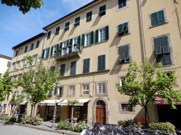
We haven’t spent a lot of time in Devonport since moving to Tasmania, despite living only a half hour drive away. On the banks of the Mersey River, Tasmania’s third largest city has undergone quite a transformation in recent years with exciting future developments in the pipeline. After spending some time at Mersey Bluff, we lunched at The Harbourmaster Café. The building on the left is the original, heritage listed harbourmaster’s cottage that has been tastefully extended to house the dining area.

1.Harbourmaster Cafe

The décor has a quirky nautical theme, half a rowing scull is suspended upside down from the ceiling.

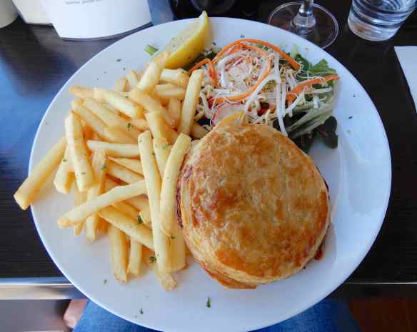
There was plenty to choose from on the menu but we couldn’t go past a Tasmanian scallop pie.

4.scallop pie

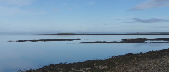
Across the water, the Spirit of Tasmania rested ahead of another overnight crossing of Bass Strait,

5.Spirit of Tasmania

destination Port Melbourne a few hundred kilometres away.

6.mouth of Mersey

There is a walking & cycle path along the river that enticed us to negate some of the calories consumed at lunch.

7.Harbourmasters Cafe

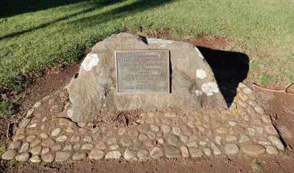
It turned out to be a very interesting stroll, with many surprises along the way. An unassuming rock is actually a memorial to commemorate the 150th anniversary of the naming of the Mersey River in 1826 by Edward Curr, chief agent of the Van Diemen’s Land Company.

8.memorial

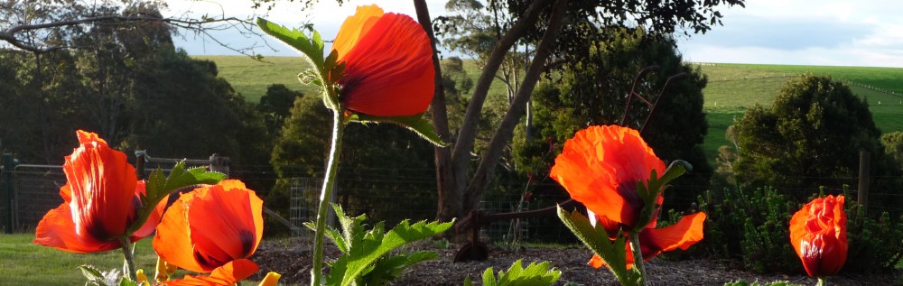
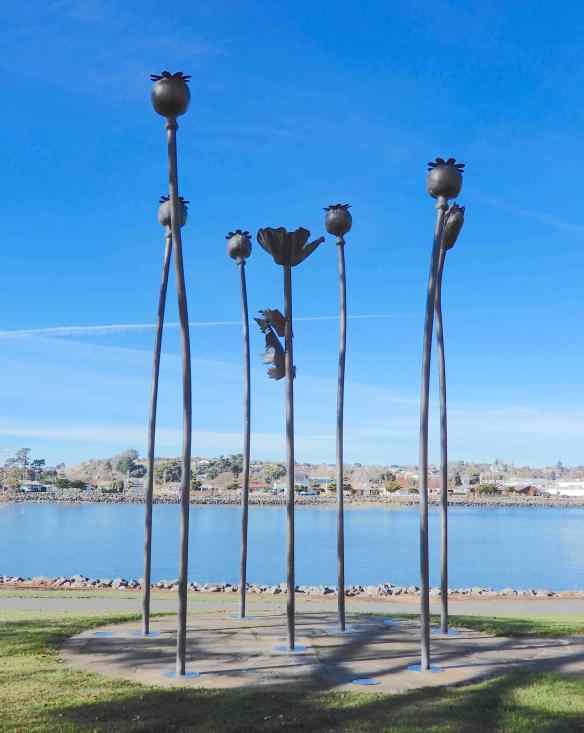
From Vision to Reality, a sculpture of bronze poppies, is a fitting tribute to the man who pioneered the Tasmanian poppy industry. Stephen King was the director of poppy research and production for Glaxo in the UK in the 1960s and 1970s. Unreliable English summers led him to seek an alternative location for poppy production and, after studying climate data, it seemed Tasmania was the answer. Since 1966, poppy cultivation has been concentrated in Tasmania where 50% of the world’s crop of legit opium poppies is now grown. Stephen King received an OBE in 1979 for his services to the poppy industry and the sculpture was erected by the poppy growers association in 2003.

9.From Vision to Reality

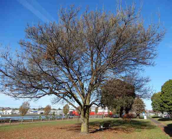
The path wends its way through well-kept lawns dotted with magnificent trees, their autumn foliage carpeting the ground.

10.tree

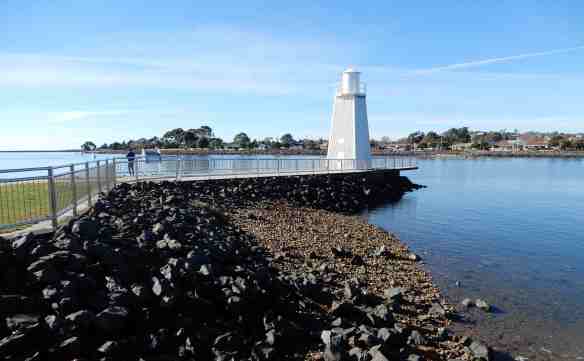
Mussel Rock is a popular fishing spot, named, not surprisingly, because of the array of molluscs found nearby. The beacon was erected in 1896 to guide vessels into the river.

11.Mussel Rock

Bronze busts of Joseph and Enid Lyons have pride of place at Roundhouse Park.

12.Enid & Joseph Lyons

Joseph was the Premier of Tasmania from 1923 to 1928  and went on to be the tenth Prime Minister of Australia from 1932 until 1939 when he died in office. He is the only Tasmanian to have been Prime Minister and the only Australian to have been both Premier and Prime Minister. Dame Enid became a politician in her own right and, in 1943, was the first woman elected to the House of Representatives. Six years later, she was sworn in as the first woman Cabinet Minister in Menzies’ Liberal government. Enid was the first woman to receive damehoods in different orders; the Order of the British Empire in 1937 and the Order of Australia in 1980. As if that wasn’t enough, Joseph and Enid had twelve children, residing at their homestead , ‘Home Hill’ in Devonport.

The Victoria Parade Cenotaph was originally erected in memory of the fallen soldiers of World War I and now commemorates those who served in other conflicts in which Australia was involved.

15.Victoria Parade Cenotaph

Next to the cenotaph is a seemingly simple fountain.

21.fountain

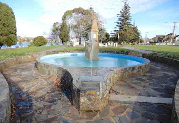
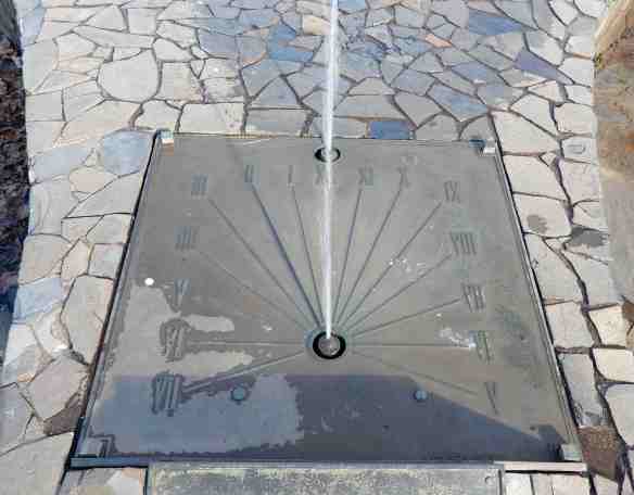
On closer inspection, the water spouts from a solaqueous fountain. The shadow on the dial made by the stream of water tells the time. As you can see, we were there at 2pm.

22.solaqueous fountain

A little further along the path is a memorial wall commemorating the 22 servicemen from Devonport who were killed at Gallipoli in 1915.

23.ANZAC Centenary Commemoration Gallipoli Campaign

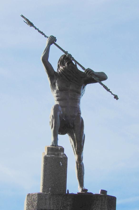
Standing alone on a rocky outcrop, Spirit of the Sea has been the source of much controversy even before it’s installation in 2009. The 700kg bronze statue was erected at the mouth of the Mersey and public opinion has been divided, so much so, the artist and his wife left the state. According to the description at the site, the sculpture reflects the elements of wind and sea and, facing the mountains, represents the connections between man, the sea and the land. I don’t really have an opinion either way but I think it would be nice to beautify the area and make a feature of the almost invisible water jets.

24.Spirit of the Sea25.Spirit of the Sea

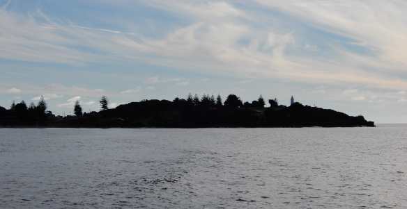
Mersey Bluff and lighthouse were silhouetted against the wispy sky in the northwest.

26.Mersey Bluff

The Vietnam Veterans Memorial Wall bears a white marble replica of the Long Tan Cross and honours those who gave their lives between 1962 and 1973 during the Vietnam War.

27.Vietnam Veterans' Memorial Wall

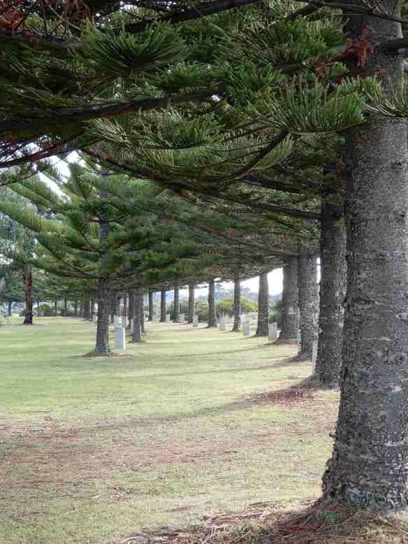
Just beyond, at the end of Victoria Parade, is a restful avenue of Norfolk Island pines. Between the trees, each plinth bears a plaque to commemorate the seventeen Tasmanian servicemen who did not return from the Vietnam War.

28.Norfolk Pines memorial

There is more to Devonport than meets the eye, we shall return soon.

Dingle

Leaving the Cliffs of Moher, our destination was the Dingle Peninsula, the westernmost part of Ireland and all of Europe. Rather than stay in the large town of Tralee, considered the start of the peninsula, we continued on to Dingle and found wonderful accommodation at Benner’s Hotel. I will always remember the delicious meal we had, the best duck breast I have eaten before or since.

1.Benner's Hotel

Next morning, after a short stroll around the narrow streets lined with colour,

6.Dingle7.Dingle

we set off to discover the peninsula. Slea Head Drive is a 47 kilometre loop, starting and ending at Dingle, that takes you right to the western edge of the country. The road is very narrow with occasional passing points and so, is driven in a clockwise direction. The scenery was spectacular from the outset.

8.Slea Head Drive

Our first stop was Dunbeg Fort, the ruins of the dry-stone structure, built around 800 BC, hang precariously onto the sheer cliff.

9.Dunbeg Fort10.Dunbeg Fort11.Dunbeg Fort

Used until the 11th century, the expansive views of Dingle Bay would have given plenty of warning of invasion. The rocky coastline looked very substantial

12.Dunbeg Fort

but much of the area consists of earth rather than rock. During fierce storms in January 2018, parts of the fort tumbled into the sea and it has been closed to the public ever since.

13.Dunbeg Fort

Near the fort there is a group of clocháns, fascinating beehive huts built from stone without mortar to create the ‘beehive’ appearance. Thought to date back to the 11th century, these huts were once family homes.

16.Clochain14.Clochain15.Clochain

The view from Slea Head lookout was breathtaking, although the mist obscured anything beyond Dunmore Head, the westernmost part of the peninsula.

17.Dunmore Head from Slea Head18.Slea Head

The loop road took us to a most fascinating place, Gallarus Oratory.

19.Gallarus Oratory

The 8th century Christian church is amazingly well preserved, the dry-stone walls having repelled the elements for over a thousand years.

Inside, the solidity of the walls becomes apparent around the only window, directly opposite the entrance.

22.Gallarus Oratory

Outside, there is a stone column, carved with a Celtic cross and an inscription in an old Latin script used between the 5th and 10th centuries.

23.Gallarus Oratory

There was such a feeling of peace around us, I imagine it would be quite different with a coach load or two of tourists in the warmer weather.

Mount Brandon seemed to dissolve into the clouds as we meandered our way back to Dingle. The second tallest mountain in Ireland takes its name from St. Brendan the Navigator who, according to legend, spent forty days on the mountain preparing for his voyage in search of the Garden of Eden in the 6th century.

26.Mount Brandon

It’s easy to see how Johnny Cash was inspired to write Forty Shades of Green on his visit to Ireland in 1959.

27.Dingle Peninsula28.Dingle Peninsula29.Dingle Peninsula


Suite Sofia

Anyone who has read my Italian posts will know how intrigued I am by doorways such as this.

1.front door

I could hardly contain my excitement when we arrived at our apartment in Lucca and found this was the entrance.

2.front door

I had booked Suite Sofia on the internet months ahead, choosing it because of location and falling in love with the photos (and price, of course). I am always sceptical that, in reality, some accommodation will not live up to expectations. As soon as we walked into the apartment, all fears dissipated, it was gorgeous.

3.Suite Sofia

The kitchen was compact but well serviced, we didn’t intend cooking anyway.

4.kitchen

The original ceilings have been preserved and added to the peaceful ambience,

while tasteful adornments gave the space a homely feel.

The position was perfect, overlooking cafes in Corso Garibaldi, right above a bicycle hire shop.

17.Corso Garibaldi18.Corso Garibaldi

From the outside, the building was stunning,

19.Corso Garibaldi

no traffic except for the two-wheeled silent type.

20.Corso Garibaldi

Our host, Massimiliano, was lovely, nothing was too much trouble. We will certainly return to Suite Sofia if we have the chance.

21.Suite Sofia from Corso Garibaldi

The Burren

Much as we would like to have stayed in Galway a few more days, our time in Ireland was limited and there was so much more to see. Driving southward, we were once again surrounded by enchanting scenery. Scattered farmhouses wrapped in green, stone-framed pastures overlooked peaceful waters.

1.burren road2.burren road

Just outside Ballyvaughan we encountered Irish gridlock and spent some time chatting to the farmer. We will never forget his name, it was Michael Cannon.

The landscape changed the further we drove into the region known as The Burren.

6.ruins, the burren

The great expanse of limestone karst covers around 160 square kilometres in County Clare, the rock has been dated back to the Carboniferous period, around 350 million years ago.

7.the burren

The water soluble limestone has eroded over the years and formed the channels, known as ‘grikes’ and blocks, known as ‘clints’. It’s hard to believe that when people first inhabited this area 5,000 years ago it was a lush forest. Clearing the land for farming, along with time, grazing and erosion all contributed to the appearance of The Burren.

8.limestone karst, doolin9.limestone karst, doolin

We were too late to see the array of wildflowers that bloom among the rocks in spring but there was evidence of life in unexpected places.

10.fern in limestone karst

We strolled around the quaint coastal village of Doolin with breathtaking views from the harbour.

11.doolin harbour12.doolin

Once part of the mainland, Crab Island is a renowned surfing location, though not today. The building is the remains of an 1830s constabulary outpost.

13.crab island

Further across the water, the Aran Islands are just visible. The group of three islands sit at the mouth of Galway Bay and can be reached by ferry from Doolin.

14.aran islands

There is a path along the cliffs from Doolin to the Cliffs of Moher, about an 8km walk with green fields on one side and the Atlantic ocean on the other.

15.doolin cliff walk

Not to mention spectacular scenery along the way.

16.cliffs, doolin

The Cliffs of Moher, on the southwestern edge of The Burren, are 14km of vertical cliffs rising to a height of 214 metres at the highest point. O’Briens Tower stands on that headland, built in 1835 by landowner Cornelius O’Brien as a viewing point for tourists. From Doolin, we could see beyond the tower, all the way to the rock formation known as  Hag’s Head at the southern end of the cliffs.

17.cliffs of moher, o'briens tower & hag's head

We left Doolin to have a closer look at the cliffs, passing a contented local on the way

18.doolin local

and a rather impressive edifice on a nearby hill. The 16th century Doonagore Castle has been in the same family since the 1970s and is their private holiday home. The views would be astounding.

19.doonagore castle

We finally made it to the Cliffs of Moher in all their majesty but time was ticking on and we still had no idea where we would be spending the night.


22.cliffs of moher


monkey business

The last thing you expect to find in a city park is a troop of Japanese macaques. Launceston City Park has been home to a few different beasts over the years, from thylacines to brown bear and deer. It was home to a group of Rhesus monkeys from the late 1800s until the last one died in 1979. The council wanted to continue the monkey tradition and, after much research, decided the Japanese macaque is best suited to the Tasmanian climate. A fitting choice, as Ikeda City in Japan became a sister city with Launceston in 1965. The enclosure reflects the natural environment of the monkeys with plenty to keep them occupied as well as a much loved swimming pool.

1.enclosure

Time slipped away as we watched, mesmerised, these gorgeous creatures and their antics. Some sat quietly, contemplating

2.thinking

while others were in the mood to play.

3.let's play

Japanese macaques are omnivorous, although their diet here is quite different to that in the wild. Their menu includes barbecue chicken, scrambled eggs and honey sandwiches as well as fruit and vegetables. Some were intently picking through the mulch, probably looking for treats of dog biscuits and bird seed that had been hidden there.

There was much grooming going on, a way of maintaining social bonds

but it wasn’t going to interrupt breakfast for this youngster.

The babies are adorable,

some stayed close to mum.

Relaxing peacefully in the sunshine was enough for others on this beautiful Sunday morning.

26.contemplation

29.how shall i spend the day?

I wonder whether the monkeys wait each day for the human exhibit to arrive?